We Buy Houses In Greater Sudbury & Surrounding Areas
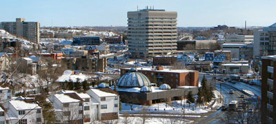
SUDBURY DOWNTOWN
The downtown of Sudbury is bounded by Ste-Anne Road/Davidson Street to the north, Douglas Street at Brady/ Elgin Street at Howey Drive to the south, Kitchener Street to the east and Alder Street to the west, and includes one of the city’s largest concentration of retail businesses and offices. Specifically the Rainbow shopping center and Tom Davies Square, the city’s modern city hall A parcel of this land adjacent to the city hall was later donated by the city to the Sudbury Theatre Centre. The city has struggled in recent years to maintain a vibrant downtown. Recent projects have included the creation of Market Square, a farmers’ and craft market, the redevelopment of the Rainbow Centre mall, streetscape beautification projects. At various times over the past 50 years, the city and community groups have proposed that the city purchase the CPR stockyards west of Elgin Street in order to expand the downtown area, although to date this has not been pursued. One of downtown Sudbury’s more unusual features is a five-acre park on the hill on Van Horne Drive in the southeast corner of the neighborhood, centered on a grotto dedicated to Our Lady of Lourdes.
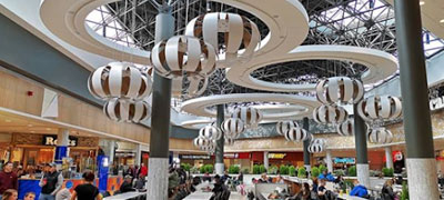
NEW SUDBURY
The New Sudbury area, centered on Lasalle Boulevard running east–west and BarryDowne Road running north–south. In French, it is known as le Nouveau-Sudbury. It includes a mix of commercial development along LaSalle, such as the New Sudbury Centre, the largest shopping mall in Northern Ontario,[15] and residential properties on most of its streets. This community is home to the Adanac Ski Hill/Rotary Park/Nickedale Moraine, as well as Timberwolf Golf Course and Cambrian College.
VALLEY EAST
(Vallée-Est in French) is a district of the city of Greater Sudbury, Ontario, Canada. The largest of the six towns in the Regional Municipality, it was reincorporated as a city in 1997 due to continued population growth. On January 1, 2001, the city and the Regional Municipality were dissolved and amalgamated into the city of Greater Sudbury. Valley East Days is the largest Free Family Festival in Northern Ontario, and celebrated its 44th year in 2019. This three-day long festival has included big musical acts, such as Trooper & Chilliwack in 2017. The festival typically attracts over 25,000 patrons.
MINNOW LAKE
One of the older residential areas in the former city, is centered on Howie/Bellevue/Bancroft Drives between the Kingsway (Municipal Road 55) and the north shore of Ramsey Lake, west to Moonlight Avenue. The small lake known as Minnow Lake once had a saw mill operating on its shore, now there is the Millennium Fountain that shoots water in the air with colored lights. Minnow Lake is home to the Silver City, Sudbury Curling Club, Carmichael Arena and its skateboard park, the Civic Memorial Cemetery and Branch 76 of the Royal Canadian Legion, which boasts a WWII Sherman Tank. There are also scenic trails around the lake and up the nearby rocky hills both at Blueberry Hill and Oak Forest. There are three elementary schools in Minnow Lake: Adamsdale Public School, Pius XII Catholic School and École St-Pierre.
GATCHWELL
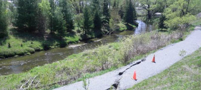
This area is south west of downtown, nestled between the West End and Copper Cliff’s industrial area, centered on Lorne Street between the Big Nickel and Regent Street at Ontario Street. The slag heaps framing this neighborhood are in the process of being turned into green hills, disguising a century of slag dump build-up, 300m high. The community has four public elementary schools and three Catholic elementary schools. The age of the community has provided a number of smaller shops and services conveniently scattered throughout its own commercial district mainly along Lorne Street. There are several large commercial and light industrial business as well.The community is home to the Gatchell indoor swimming pool. Junction Creek is a natural landmark in this area and is currently undergoing a transformation as the Trans-Canada Trail is being constructed through the vacant lands along its banks. The neighborhood’s primary features are the Big Nickel numismatic monument park with its Dynamic Earth Centre and ‘Delki’ Dozzi Park, a park and sports complex that defines almost the entire northern boundary of the neighborhood.
COPPER CLIFF
This area is south west of downtown, nestled between the West End and Copper Cliff’s industrial area, centered on Lorne Street between the Big Nickel and Regent Street at Ontario Street. The slag heaps framing this neighborhood are in the process of being turned into green hills, disguising a century of slag dump build-up, 300m high. The community has four public elementary schools and three Catholic elementary schools. The age of the community has provided a number of smaller shops and services conveniently scattered throughout its own commercial district mainly along Lorne Street. There are several large commercial and light industrial business as well.The community is home to the Gatchell indoor swimming pool. Junction Creek is a natural landmark in this area and is currently undergoing a transformation as the Trans-Canada Trail is being constructed through the vacant lands along its banks. The neighborhood’s primary features are the Big Nickel numismatic monument park with its Dynamic Earth Centre and ‘Delki’ Dozzi Park, a park and sports complex that defines almost the entire northern boundary of the neighborhood.
WEST END
The West End is the area located immediately west of downtown, centered on the intersection of Regent and Victoria Streets up to the westernmost end of the original city limits, south to Byng Street. The neighborhood is primarily residential in character with some commercial properties along Regent Street and community facilities including Queens Athletic Park, with its track & field oval that becomes a skating oval over the winter.
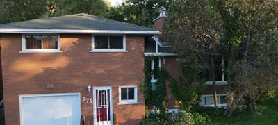
SOUTH END
The South End is currently one of the fastest-growing areas of the city, with significant commercial and residential development taking place especially in the Algonquin Road area. The South End of Sudbury includes the urban neighborhoods of Robinson, Lockerby, Moonglow and Lo-Ellen. The center of the area is the Four Corners, a major commercial shopping district centered on the intersection of Regent Street, Paris Street and Long Lake Road. The Southridge Mall, located on the southeast quadrant of the Four Corners, is currently undergoing a major expansion. The south end also includes Bell Park. The arts and crafts movement mansion of William J. Bell for whom this neighborhood is named is in the heart of this area. It is currently home to the Art Gallery of Sudbury. The park’s amphitheater is near the boardwalk connecting the park to the nearby Science North center, which is Northern Ontario‘s most popular tourist attraction which includes an IMAX theatre. Other notable buildings in this area include the Water Pumping Station/Hydro Building, the Sudbury Yacht Club on Blueberry Island, Idylwylde Golf & Country Club, Health Sciences North (hospital) and Laurentian University.
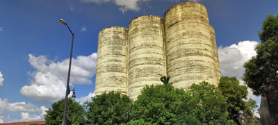
FLOUR MILL
The Flour Mill neighborhood is centered on Notre-Dame Avenue and Kathleen Street, immediately north of downtown Sudbury, One of the city’s first neighborhoods outside the original settlement, Most notable surviving building, a large flour mil l silo, was operated by the Manitoba and Ontario Flour Mill company starting in 1910 and was designated a city heritage property in 1990. It celebrated its Centennial in 2011. The historic home of the mill’s foreman was converted to a community museum, the Flour Mill Museum, in 1974. There is a parkette and historic plaque at the base of the silo. Other notable landmarks include the Catholic parish church of Église St-Jean-de-Brébeuf – 26 Kathleen St (Kathleen and Notre-Dame). Stone church with green spire.
DONOVAN / NORTHERN HEIGHTS
Centered on Frood Road northwest of downtown, Donovan refers to the area immediately surrounding the intersection of Frood, Kathleen and Beatty, the lands between the two sets of railroad tracks. While Northern Heights refers to the newer neighborhood built in the 1970s to the north, between Rio Road (1964) and St-Roch Lane (1983) The area’s narrow lots and laneways give it a distinctive appearance. After WWII, the area was settled by many Eastern European immigrants, mainly from Ukraine, Poland, Finland and the former republic of Yugoslavia. Each of these ethnic groups founded community halls in the Donovan.
LIVELY
The administrative and commercial centre of Walden, Lively was established in the 1950s as a company townsite for employees of INCO‘s Creighton Mine facilities. It was named for an early settler, Charles Lively. Prior to the community’s establishment, a few family farms were located in the area. The most notable of these, the Anderson Farm, is now the Anderson Farm Museum, which showcases aspects of the history of Lively, Creighton, and Waters Township From the intersection of Municipal Roads 24 and 55, Lively refers to the area extending north along MR 24. Lively is also home to the Walden area’s branch of the Greater Sudbury Public Library.
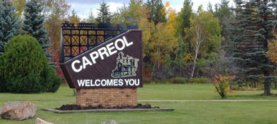
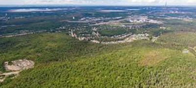
CAPREOL
Capreol formed around the Capreol railway station, which was a major divisional point on the Canadian National Railway line. Its name comes from Frederick Chase Capreol, the original promoter of the Northern Railway of Canada. Although the town was originally an independent community with its own thriving economy, it gradually became a satellite community to the more rapidly growing city of Sudbury, approximately 40 kilometres to the south. In 1973, the boundaries of the town of Capreol were expanded to include the nearby villages of Sellwood and Milnet, and the town was incorporated into the Regional Municipality of Sudbury. However, despite its status as part of the regional municipality, during this era Statistics Canada did not include the town in Sudbury’s Census Metropolitan Area.

AZILDA
The community borders the shores of Whitewater Lake, except for its most western portion. Municipal Road 35, linking Azilda to downtown Sudbury, has been increased from two lanes to four lanes, which has improved the commute for Azilda’s workers, who are mostly employed in the city’s urban core. In addition, it shortens the travel time for tourists hoping to visit Sudbury Downs, which is located in the outskirts of Azilda. There are plans to complete the widening of Municipal Road 35 between Azilda and Chelmsford, on which construction began in 2019. While the population is still growing, there are no industries other than basic agriculture (corn, potatoes, beans) and horticulture. Much of the workforce travels to Sudbury to make their living, oftentimes in the primary industries such as mining. Azilda has its own flag that was revealed in 2021.
CHELMSFORD
Chelmsford started out as an outpost on the Canadian Pacific Railway. Some say Chelmsford was named by one the Canadian Pacific Railway engineers, who was from the United Kingdom. As with many communities in Northern Ontario, logging and fur trapping were the first industries. Having depleted the lumber in the early 1900s, Chelmsford turned to mining and agriculture to support the town’s economy. Today, Chelmsford has no major industries and is mostly a residential community. Although there are still some farms producing mostly potatoes, small fruits and corn, it is mostly supported by the mining activities in nearby communities. Chelmsford is host to an annual fiddle festival, Fiddle Works, in May.